Reef sweep to check vitals
 Print
Print NASA is undertaking a high-tech review of the Great Barrier Reef's health.
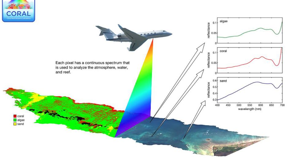
A sensor mounted on a Gulfstream jet will make a month worth of passes over the Reef, capturing images of six key sections from the Torres Strait to Heron Island.
“Unlike your smart phone or SLR camera that take pictures in three colours, this camera takes pictures in 250 colours from ultraviolet to infrared,” says Bermuda Institute of Ocean Sciences lead researcher Eric Hochberg.
“When you go scuba diving or snorkelling you put on a mask, which is literally putting blinders on.
“From 28,000 feet we can see the whole Reef, we can see the entire ecosystem in one picture instead of looking at bits of it and trying to piece it together.
“With that detailed information, we're able to tell what the atmosphere is over the Reef, we're able to tell how deep the water is, what's in the water and of course what's on the bottom.”
Underwater surveys at Lizard Island and Heron Island will be used to verify and add detail to the bird's-eye images.
CSIRO experts are excited about the opportunity to test the new prism-style sensor apparatus, which will soon be the standard for satellite sensors in space.
The scientists say the data will help develop tools to guide Reef management by the Queensland Government and the Federal Government.
The flying lab will then move on to other Pacific reefs in Hawaii and Palau.