


Third La Niña looms
 Print
Print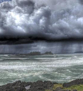 Four out of seven forecasting models are predicting La Niña will return to Australia in late spring.
A third consecutive La Niña would be a concerning development for Australians, according to researchers at the ARC Centre of Excellence for Climate Extremes.
“La Niña has been on the mind of many Australians for two years in a row” says Dr Zoe Gillett, Centre Research Fellow.
“La Niña is an ocean temperature and wind pattern across the Pacific Ocean. It has global impacts and promotes increased rainfall over much of Australia.
“Eastern Australia has experienced extreme rainfall and flooding associated with La Niña for two consecutive summers.
“These events have affected entire communities across large parts of the country and impacted our agriculture and supply chains.
“La Niña in two consecutive summers - what we call a double-dip La Niña - is not uncommon and happens in about 50 per cent of events.
“This persistence can increase climate risks due to increased rain falling on already saturated catchments.
“It’s concerning that some climate models are predicting that a third consecutive La Niña could form later this year.
“Triple-dip La Niña events are rare and have only happened twice since 1950. However, it is currently too early to tell if a third La Niña will eventuate.
“As of June, four out of seven forecasting models are predicting La Niña will return in late spring. The possibility of more rain falling on already saturated catchments would be a concerning development for communities still recovering,” she said.
A full briefing on multi-year La Niña events from the Centre is available here.